
Secrets of the Creeklands – A Whimsical Walk
This page describes a whimsical walk through the Creeklands highlighting lesser known facts and features.

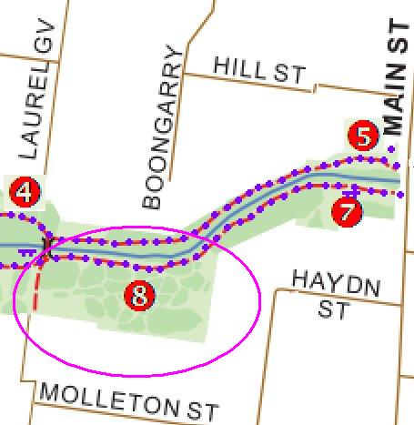
The Secrets of the Creeklands Walk – click to enlarge
It will take about an hour at a medium pace taking time to see the sights. Most of the track is flat – however, there are a couple of small climbs to make. Seats/rest points are marked on the map. You’ll need to carry your own water.
The walk starts at the noticeboard. There is usually parking available next to the Blackburn Bowling Club or over the road near the Scout Hall (nb: busy at school times).
Of course you can start anywhere you like and travel in any direction for all or part of the walk – but unless you are travelling clockwise you might find “The Cutting” harder to find and the mower track between “The Woodland” and “The MMBW House” is fairly steep – so better going downhill!
The following describes the walk in overview. Click on the link in the heading to find out more about that particular stop.
-
First stop is the Brandenburg Line
The Brandenburg Line refers to a former path, straight as a die – leading directly from Albion Street to the Scout Hall.
Starting at the Noticeboard, head towards Middleborough Road. Cross Pakenham Street into Blacks Walk and walk through the car park, with the Scout Hall on your right, to join the park path that runs parallel to the Laburnum Primary School fence. You will find a seat almost at Middleborough Rd where the path curves around to the north and another path leads to the Middleborough Road/Albion Street intersection.
-
The next stop is Blackburn Creek

Did you know the original name for Blackburn was Blackburn Creek?
Walk from the Brandenburg Line along the creekside path. Just before crossing the bridge, look to your left at the shot-put concrete ring. Who put it there? Was it ever used? (This may be covered in a forthcoming Mysteries of the Creeklands…). Cross at the first bridge towards Garie Street, follow the track to the west of the Guides Hall past the rather majestic Yellow Box eucalypt and you can stand above where Blackburn Creek emerges from its modern, subterranean existence next to the chain mesh fence.
In the early 1960s, the well known landscape designer Ellis Stone put forward a concept plan for the Blacks Walk hill further along the track. A few rocks (stones?) still exist from those days.
-
The Cutting and Tasmanica Terrace
Double back and take a short cut through the Garie Street playground to join the fairly new track (built in 2012) and walk back to Pakenham Street, cross over the road and follow the track along the northern (left hand) side of the creek.
 After you pass the bollards, travel up the small rise – the cutting is 15 metres after the seat – look for the tree stump near the path, more or less atop the rise.
Incidentally, you just walked through the “Frog Bog” – a habitat designed for frogs which unfortunately hasn’t worked – no frogs have taken up residence (unlike at the Waratah Wetlands ahead).
A little further on your right is “Tasmanica Terrace” – it’s on the kink in the creek and is named after the long, strappy Dianella tasmanica plants doing so well there.
 Continue along the path through the Waratah Wetlands* towards Laurel Grove.
If you peer through the Hymenanthera shrubbery, to the north, just before Laurel Grove, you will see a strange oblong box. It certainly looks ominous. The rationalist explanation is that it is a standard council toolbox for working bee equipment.
*The Waratah Wetlands was a Bicentennial Project and is a great spot for frogs. It is filled by water not only from the hillside but also via a channel that runs from Laurel Grove.
Waratah Crescent is actually a crescent shape and there is a road reserve (closed) that originally ran from Acacia Rd around to Laurel Grove.
 Walk along the northern track almost as far as Main Street. This path was the only connection between the Creeklands and Main St until 1982*.
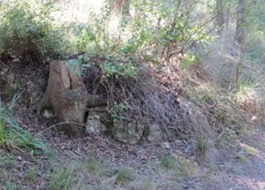
In the far NE corner of Kalang Park, you’ll notice a large stump on the boundary of private land at 60 Main Street. The bollards mark the boundary at strategic points. This was long thought to be an aboriginal scar tree. Please be careful of the young plants in the area if going for a closer look.
*Earlier still, before the Main Street bridge was built, some of the local lads made a little spare money by piggy-backing people (mainly girls) across the creek.
 From the scar tree, cross main street and continue along the northern path, under the “tree arch” as far as the seat about two thirds of the way up the hill.
Just before turning off the main track look slightly to your left at the land at the bottom of Gardenia St on the east side:
- It was here almost 100 years ago that the Education Department established its Open-Air School.
- It was developed in 1915 to take children who were ‘markedly inferior in nutrition and general health’ from the Fitzroy and Collingwood areas. They would be transported by train and fed on milk and soup and spent large amounts of time outside bird observing and walking in Furness Park.
- The school hit its peak after WWII when up to 24 children were attending. They studied a Grade 3 or 4 program and could attend for up to one year. By this time a bus was used to pick up the children each day. The school closed in 1964 and was used by Department’s psychology and speech therapists for another 20 years.
From there walk across the grass towards the Furness Street bridge (about 30 degrees to the right) as far as the top of the mower track which descends fairly steeply towards the bridge.
There is a convenient log there for a break – ideally positioned so you can see the creek both facing to the east, and, to the south.
From the Woodland, either take the mower track (slippery when wet) or return to the main path and follow it around to the black Furness Bridge. This bridge is fairly new having been constructed in 2010. Cross the bridge and walk back towards Main Street by turning right at the top of the hill where the path forks past the Heath St playground. Just after the playground, look into the trees. This is a great place for observing Rainbow Lorikeets, Corellas and Galahs.
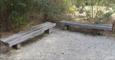
Cross Main Street and look for the “Community Seat” – two seats at right-angles.
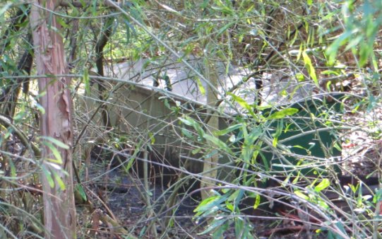
There used to be a house owned by the MMBW (now Melbourne Water) at 62 Main Street. It was demolished in 1984 to improve park accessibility and was incorporated into the park.
 From the community seat, walk along the track and keep an eye on the vegetation to the south. As the park widens, you’ll notice a series of “islands” of plantings on the south side of the creek in the middle between Main Street and Laurel Grove.
You may have noticed that kids love running through there taking the many twists and turns the area offers.
 Travel past the Laurel Grove bridge until you reach the next path heading southwards at an angle which heads towards Sheehans Rd. Walk up towards Harry St but turn west in the grass area on the informal track.
A remnant historic pear orchard of seven pear trees still remains at the southern end of the park (in Kalang Park) between Sheehans Road and Malcolm Street – almost at Malcolm Street.

From the orchard keep walking west along the bottom of the Kalang Park oval towards the noticeboard. The Ole Oak Tree stands alone as, perhaps, another anomaly in the park – being a quite old English tree.
References and acknowledgements: The author acknowledges conversations with Mary Crouch, Alan Lodge, Nan Anderson, Megan and Peter Short which informed this “walk”. After reviewing a preliminary version, Megan and Peter supplied helpful suggestions and provided additional material. Other references were:
- Suburban Heartland – A History of the City of Whitehorse by Lesley Alves, 2010
- Windows on Nunawading by Diane Sydenham, 1990
- Blackburn – A Picturesque History by Robin Da Costa, 1978
- Box Hill by Andrew Lemon, 1978
Thanks too to Friends Wendy and Colin who tested our original instructions and suggested clarifications that have now been incorporated.

Pingback: Park News – June, 2014 | The Blackburn Creeklands
Pingback: Park News – January, 2015 | The Blackburn Creeklands
Pingback: Park News – February, 2015 | The Blackburn Creeklands
Pingback: Park News – January, 2017 | The Blackburn Creeklands
Pingback: Park News – December, 2019 | The Blackburn Creeklands